Autumn Gear Guide
Find inspiration in our Gear Guide that will keep you out on your bike through wind or rain.
Download Now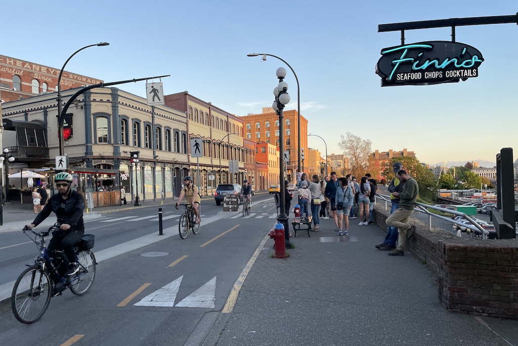
In an era where city streets are expected to do more than just move cars, urban planners are increasingly turning to a deceptively simple concept with transformative potential: the road diet. But despite decades of success stories and an impressive body of data supporting their benefits, the term still raises eyebrows—and tempers—among skeptics worried about […]
In an era where city streets are expected to do more than just move cars, urban planners are increasingly turning to a deceptively simple concept with transformative potential: the road diet. But despite decades of success stories and an impressive body of data supporting their benefits, the term still raises eyebrows—and tempers—among skeptics worried about traffic congestion and parking.
So, what exactly is a road diet? And why has this traffic-calming strategy become such a cornerstone of modern urban design?
At its core, a road diet is a reconfiguration of a roadway that reduces the number of lanes dedicated to cars. Typically, this means transforming a four-lane road into three lanes—two for through traffic and one center lane for shared left turns. The space gained from this downsizing is then repurposed for other uses, such as bike lanes, wider sidewalks, bus-only lanes, pedestrian islands, or green space.
The idea isn’t new. The first road diet in the United States was implemented in 1979 in Billings, Montana. Since then, cities like Charlotte, Chicago, San Francisco, and New York have all embraced the model. But it’s not just a design trend—road diets are backed by powerful data and safety results.
The Toronto Region Conservation Authority says that, at its core, “a road diet is a reconfiguration of a roadway that reduces the number of lanes dedicated to cars.”
One of the strongest arguments for a road diet is safety. According to the U.S. Federal Highway Administration (FHWA), four-lane undivided roads experience relatively high crash rates, particularly as traffic volumes increase. These crashes are often the result of speed, aggressive passing, and conflicts between turning vehicles and through traffic.
By narrowing the number of lanes and reducing average speeds, road diets have been shown to cut crashes by 19 to 52 percent. Slower speeds also mean that, when collisions do occur, they are far less likely to be fatal—especially for vulnerable road users like pedestrians and cyclists.
And when those repurposed lanes are turned into protected bike lanes or pedestrian zones? That’s when streets start to truly embrace the “Complete Streets” philosophy: making room for all users, not just cars.
The most common criticism of road diets is that they increase congestion by reducing vehicle capacity. But the data tells a different story.
Removing travel lanes can actually lead to a reduction in overall vehicle trips—a phenomenon known as traffic evaporation. Some drivers shift to alternative routes or, increasingly, to alternative modes of transport. When bike lanes or better sidewalks are introduced, more people feel comfortable cycling or walking instead of driving. And when a bus-only lane is added, public transit becomes a more viable option, further reducing the number of cars on the road.
Case in point: Ocean Park Boulevard in Santa Monica. After being reconfigured from four lanes to three, with the addition of bike lanes, the city saw a 65% reduction in crashes—and no significant increase in congestion on nearby streets.
Bike lane in Victoria, BC
There’s another bonus to all this: lower emissions. By shrinking road space for cars and encouraging walking, biking, and transit, road diets reduce overall Vehicle Miles Traveled (VMT). That translates into fewer greenhouse gas emissions—a win for cities looking to meet their climate targets.
Calmer traffic also means more efficient driving. Cars burn more fuel and produce more emissions at higher speeds and during stop-and-go conditions. Road diets help smooth the flow and temper speed, making streets not only safer but greener.
Not every road is a candidate for a diet, which is why planners rely on a suite of metrics—like Annual Average Daily Traffic (AADT), Vehicle Miles Traveled (VMT), and Turning Movement Counts (TMC)—to assess viability.
Modern traffic analytics, including GPS-based Origin-Destination tracking and real-time speed data, can pinpoint high-risk corridors where road diets could be most effective. These tools also allow planners to run before-and-after studies to show real-world results and address community concerns with hard data.
Take Armour Road in North Kansas City. After a road diet was implemented, including protected bike lanes and pedestrian islands, a study showed vehicle speeds dropped significantly, biking activity doubled, and average travel times rose by only five seconds. That kind of outcome speaks volumes.
Despite the successes, road diets often face pushback. Residents worry about increased travel times, emergency vehicle delays, or reduced access to local businesses. But with data-driven planning and community engagement, many of these concerns can be addressed—or even reversed.
In fact, safer streets often boost local businesses by attracting more foot traffic and cyclists. And emergency response times can remain unchanged if planners work with local services to ensure adequate alternate routing.
For cycling advocates, road diets offer a powerful, data-driven framework to support reallocating space from cars to bikes. Instead of framing bike lane installations as taking something away from drivers, road diets present them as safety upgrades that benefit all road users.
By converting excess travel lanes into protected bike lanes, wider sidewalks, or center turning lanes, road diets reduce speeding and collisions—often by up to 52%, according to the Federal Highway Administration—while maintaining reasonable travel times. According to Streetlight Date, in North Kansas City, for example, a road diet on Armour Road added bike lanes and reduced speeding, with travel times increasing by just five seconds.
Data is key. Metrics like AADT (Annual Average Daily Traffic), crash history, and vehicle speeds help identify streets where road diets will be most effective, and give advocates tools to respond to concerns about congestion or lost parking. These changes also support broader city goals around climate, public health, and safety.
As cities aim to reduce car dependency and create safer, more livable streets, road diets provide a strategic language and evidence base advocates can use to push for permanent cycling infrastructure.
The road diet isn’t about punishing drivers. It’s about creating streets that work better for everyone—from the parent pushing a stroller to the teenager biking to school, the delivery driver navigating a tight urban corridor, or the senior walking to the store.
As our cities continue to evolve, road diets offer a cost-effective, data-backed, and scalable way to make them safer, cleaner, and more livable. It’s not just about losing a lane—it’s about gaining a better future for urban mobility.
Find inspiration in our Gear Guide that will keep you out on your bike through wind or rain.
Download Now


Leave a comment