Autumn Gear Guide
Find inspiration in our Gear Guide that will keep you out on your bike through wind or rain.
Download Now

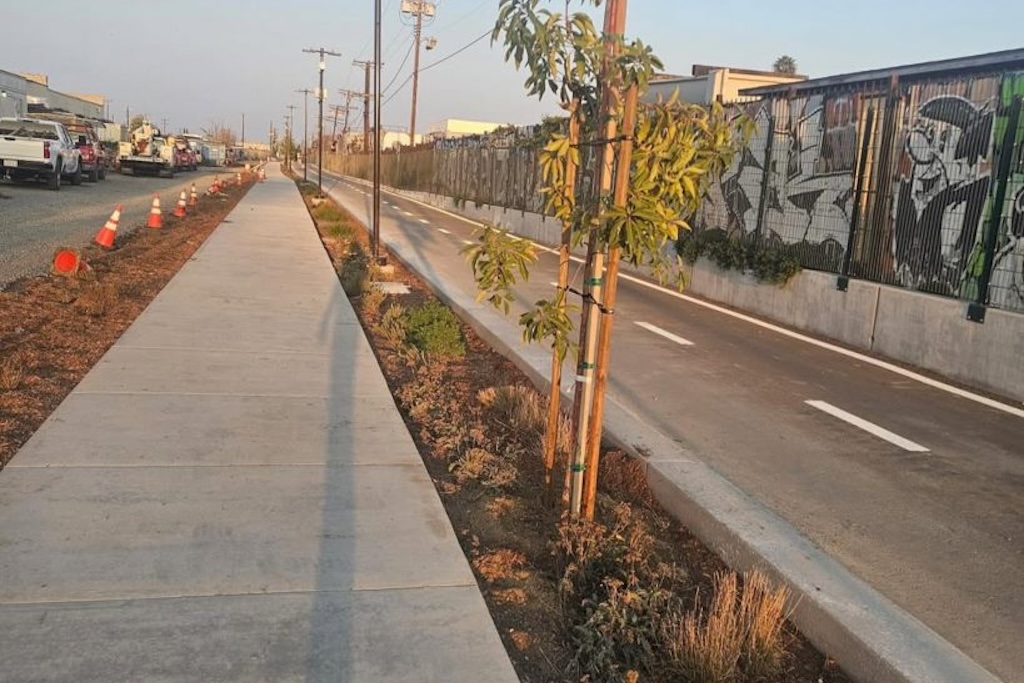
The newly completed Rail-to-Rail Active Transportation Corridor, a 5.5-mile pedestrian and bike path carved from a forgotten freight corridor, is not just a new infrastructure project. In a city built on movement, where freeways often define geography and transit lines draw invisible boundaries between communities, Los Angeles is quietly rewriting its story—mile by mile. It’s […]
The newly completed Rail-to-Rail Active Transportation Corridor, a 5.5-mile pedestrian and bike path carved from a forgotten freight corridor, is not just a new infrastructure project. In a city built on movement, where freeways often define geography and transit lines draw invisible boundaries between communities, Los Angeles is quietly rewriting its story—mile by mile. It’s a statement of values: that mobility belongs to everyone, and that even the most overlooked stretches of urban space can become places of connection, community, and care.
Set to officially open to the public on May 17, with a community celebration along Slauson Boulevard, the path runs east from the K Line’s Fairview Heights Station in Inglewood to the A Line’s Slauson Station. Along its course, it threads together Hyde Park, Chesterfield Square, Vermont-Slauson, Florence-Graham, and Central Alameda—communities historically underserved by traditional transportation planning.
The result is a Class I protected bicycle and pedestrian corridor that is both practical and symbolic: a reclaimed right-of-way transformed into a continuous, accessible, and vibrant artery for walking, rolling, and riding.
Long before bikes and joggers began moving along this newly paved route, the land underfoot was part of the Harbor Subdivision, a freight rail corridor built in the early 20th century to link Downtown Los Angeles to the ports of Wilmington and San Pedro. Trains carried goods through Redondo Beach, Torrance, and other South Bay cities, feeding the industrial growth of a booming region. But by the 1970s, the clatter of cargo trains had gone silent. The last true freight train passed along Slauson Avenue in 1974.
Over the next few decades, the corridor sat mostly idle. In the early 1990s, the Los Angeles County Transportation Commission—one of Metro’s predecessor agencies—purchased a stretch of the corridor for potential reuse. Various proposals were floated: a Metrolink route, light rail, even bus rapid transit. But it wasn’t until 2014 that a new idea took hold: an active transportation corridor for pedestrians and cyclists.
The idea came at a moment of broader reimagining. Across Los Angeles County, cities were beginning to see the value of transforming underused infrastructure into green mobility corridors. From Burbank’s Chandler Bikeway to the path alongside the E Line, these spaces became powerful examples of how public space could serve human-scale transportation. Rail-to-Rail would be the most ambitious yet.
Spanning a 30-foot-wide former rail right-of-way, the Rail-to-Rail project wasn’t simply designed for efficiency. It was designed to honor and reflect the needs of the communities it runs through. Years of community engagement, workshops, and feedback helped shape everything from the width of the walking path to the placement of shade trees and benches.
The result is a corridor that reflects both thoughtful design and intentional equity. The 7-foot walking pathaccommodates a diversity of users—from dog walkers and joggers to seniors and parents with strollers—while a parallel two-way bike lane is buffered from foot traffic by planted bioswales and painted lanes. Bollards, signage, and clear markings help minimize conflict points, particularly at intersections and “mixing zones.”
Lighting was another key request. Now, 498 high-efficiency LED lights line the corridor, equipped with full cutoff optics, motion sensors, and bullet-resistant lenses. Emergency blue phones are spaced throughout, and security cameras—52 in total—monitor the corridor to ensure safety for all users.
But security doesn’t mean sterility. The corridor is alive with visual identity and ecology. Desert plants, colorful wayfinding signage, drought-tolerant landscaping, and native trees provide a vibrant and varied visual experience. Where once there was gravel and ballast, now there are blooming yarrow, trumpet vines, and boulders arranged alongside pedestrian buffers. In time, the trees will grow into a shaded canopy that cools the path and softens the street edge.
Rail-to-Rail Active Transportation Corridor in Los Angeles
Perhaps the greatest strength of the Rail-to-Rail path is its seamless integration with existing transportation infrastructure. Though it was built along the bones of old freight, the corridor is deeply connected to LA’s modern mobility network.
At its western end, it begins at the Fairview Heights Station on the K Line, then continues east to intersect with the J Line at the 110 Freeway and concludes across from the Slauson Station on the A Line. Along the way, it connects with Metro Bus Line 108, one of the city’s highest-ridership lines, and intersects with numerous other lines, including the 210, 207, 53, and 754. DASH service from LADOT adds local connectivity.
To encourage multimodal travel, the project incorporates five new Metro Bike Share stations, expanding 24/7 access to short-trip bike rentals. These new stations support Metro’s broader Bike Share expansion strategy, which aims to increase equitable access, reduce first-last mile gaps, and boost transit ridership through an integrated TAP fare system.
The Rail-to-Rail corridor was also selected as one of the flagship projects under Metro’s Twenty-Eight by ’28 Initiative, an ambitious effort to complete key infrastructure projects before the 2028 Olympic and Paralympic Games.
Though the current 5.5-mile segment is a major milestone, the vision is bigger. Plans are already underway to extend the corridor eastward to the Los Angeles River, which would create an unprecedented continuous greenway across the southern spine of LA.
This second phase is not just a technical expansion but a cultural and environmental one. It would connect additional neighborhoods, create access to riverfront green space, and lay the groundwork for further links into regional trail systems and open space networks.
As the corridor continues to evolve, its influence may extend well beyond Slauson Avenue. It represents a shift in how Los Angeles imagines public space—where community-led design, historical awareness, and mobility equity come together.
This Saturday, the community will gather at Slauson Boulevard between Normandie and Budlong Avenues for the corridor’s grand opening celebration. There will be food trucks, live music, booths from community organizations, and a group walk, ride, and roll along the new path.
But the celebration is about more than ribbon-cutting. It’s about reclaiming space. For decades, the Slauson corridor was defined by rails that served industry and freight. Now, it serves people. From residents commuting by bike to schoolchildren walking to class, from dog walkers to weekend joggers, the corridor belongs to everyone.
The Rail-to-Rail path may have begun as a feasibility study and a stack of design concepts. But today, it is a real and rooted part of Los Angeles—a space where past and future meet on foot, at street level, under the shade of newly planted trees.
Rail-to-Rail Grand Opening
📍 Slauson Blvd between Normandie and Budlong Avenues
📅 Saturday, May 17 | 2:00 PM – 4:30 PM
🎉 Music, food, community booths, and a group ride/walk/roll
Find inspiration in our Gear Guide that will keep you out on your bike through wind or rain.
Download Now

Leave a comment